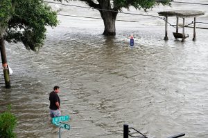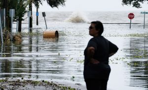
Miami, Jul 13 (efe-epa).- Barry made landfall at around midday Saturday near Intracoastal City, Louisiana, not long after gaining enough wind speed to become the first hurricane of the 2019 Atlantic season.
Although it quickly weakened back to tropical storm status over land, the torrential rains and storm surge associated with Barry are expected to cause severe flooding in that low-lying part of the United States, the National Hurricane Center said in its latest bulletin at 2 pm Miami time (1800 GMT).
Louisiana’s southern coast and other parts of the north-central coast of the Gulf of Mexico were being lashed by strong winds and torrential rains and are on alert for storm surge, while tens of thousands of homes and commercial establishments have been left without power.

“Although the center is now over land, the rainfall threat is just beginning for many locations,” the Miami-based NHC said on Twitter.
Barry became the first hurricane of this year’s Atlantic season late Saturday morning, shortly before making landfall.
Subtropical Storm Andrea had formed to the south-southwest of Bermuda on May 20, 12 days before the official June 1 start of the Atlantic hurricane season, although it rapidly weakened and did not cause any damage.
The NHC said in its latest bulletin that Tropical Storm Barry was located about 10 kilometers (five miles) northeast of Intracoastal City, Louisiana, and about 50 km south-southwest of Lafayette, Louisiana.

“On the forecast track, the center of Barry will move through southern Louisiana this afternoon, into central Louisiana tonight, and into northern Louisiana on Sunday,” the bulletin said.
It was packing maximum sustained winds of 115 kilometers per hour at the time of the most recent bulletin.
“Weakening is expected as Barry moves farther inland, and it is forecast to weaken to a tropical depression on Sunday,” the bulletin said.
The NHC warned that water could reach up to 1.8 meters (six feet) above ground between the Louisiana coastal communities of Intracoastal City and Shell Beach “if the peak (storm) surge occurs at the time of high tide.”
Flooding also could be further aggravated by heavy rainfall.
The NHC said Barry is expected to drop between 25-50 centimeters (10-20 inches) of rain over south-central and southeast Louisiana and southwest Mississippi, with isolated maximum amounts of 63 cm.
“Across the remainder of the Lower Mississippi Valley and western portions of the Tennessee Valley, total rain accumulations of (10-20 cm) are expected, with isolated maximum amounts of (30 cm),” the bulletin said. EFE-EPA
